Hebden Hey Scout Centre,
Hardcastle Crags,
Hebden Bridge,
West Yorkshire
NOTE: SAT-NAV users please use HX7 7EP then follow instructions below!
OS Grid Reference SD 978 292
(or South Pennine 1:25000 Leisure map)
click here to link to the google maps website.
The nearest train station is 2½ miles away in Hebden Bridge, on the route from Leeds to Manchester.
Bus stops are plentiful in Hebden Bridge, from where you can walk the 2½ miles to Hebden Hey, or catch a further shuttle/smaller bus to Heptonstall or Slack and walk along the track - so avoiding the steep climb out of Hebden Bridge.
Exits from the M62 are J21 (Littleborough, Todmorden, Hebden Bridge) if coming from west, or J24 (Halifax, Mytholmroyd, Hebden Bridge) if coming from east.
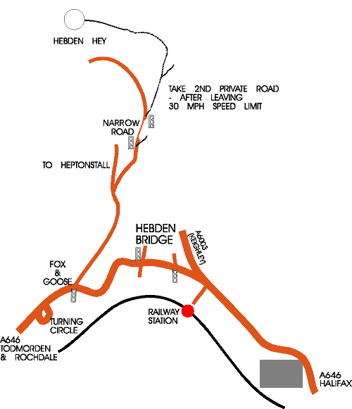
Access to the centre is along approx. 1½ miles of private single track road.
The road has been tarmaced,
yet we ask you to drive slowly; for your own sakes, as well as to avoid erosion
to the road.
DO NOT ATTEMPT to turn right BEFORE the traffic lights, this is steep, narrow, slippery and simply THE WRONG ROAD!
![]()
![]()
Please note, we are one the SOUTH side of the Hebden Water valley, there is NO suitable vehicular access between the north and south sides upstream of Hebden Bridge, so, please ensure your Sat-Nav system is going to bring you to us via the route described opposite.
Please use postcode: HX7 7EP, then follow signs along our private road.
Once you have arrived in Hebden Bridge, you can follow the directions opposite, OR take a more direct route via the public footpaths around the area.
1. Crossing the river in Hebden Bridge using the old pack horse bridge, you can then walk up the "buttress" a steep cobbled route then turn right along the road to the start of our private road - easy directions, but a steep climb!
2. Follow the river upstream, through the market square and along Victoria Road, then Spring Grove to cross the river again at the bridge, take the riverside footpath past the bowling and archery clubs to the large houses, than take the path/road up to your left past Lee Farm to come out about 1/3 along our private access, turn right and follow the track to the end - less uphill, but not as easy to navigate the first time you try.